
A Lewis & Clark Adventure With Katelyn - Page 2
| Previous | Next | Page 1,3,4,5 |
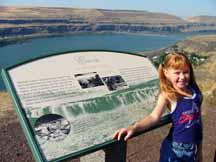 |
The next day we again headed south and stopped briefly at an overlook of what was once Celilo Falls, but is now a lake formed by the Dalles Dam. Celilo Falls (or the Great Falls of the Columbia) is where Lewis and Clark encountered a serious obstacle on October 22 and 23, 1805 in their journey down the Columbia. The journals describe the situation as follows: "... we came to seventeen huts on the right side of the river, situated at the commencement of the pitch which includes the great falls. Here we halted, and immediately on landing walked down, accompanied by an old Indian from the huts, in order to examine the falls, and ascertain on which side we could make a portage most easily. We soon discovered that the nearest route was on the right side [Washington side], and therefore dropped down to the head of the rapid, unloaded the canoes and took all the baggage over by land to the foot of the rapid. The distance is twelve hundred yards. On setting out we crossed a solid rock, about one third of the whole distance; then reached a space of two hundred yards wide, which forms a hollow, where the loose sand from the low grounds has been driven by the winds, and is steep and loose, and therefore disagreeable to pass; the rest of the route is over firm and solid ground. The labour of crossing would have been very inconvenient, if the Indians had not assisted us in carrying some of the heavy articles on their horses; but for this service they repaid themselves so adroitly, that on reaching the foot of the rapids we formed a camp in a position which might secure us from the pilfering of the natives, which we apprehend much more than we do their hostilities. ... Besides fish, these people supplied us with filberts and berries, and we purchased a dog for supper; but it was with much difficulty that we were able to buy wood enough to cook it. In the course of the day we were visited by many Indians, from whom we learnt that the principal chiefs of the bands, residing in this neighbourhood, are now hunting in the mountains towards the southwest. On that side of the river [Oregon side] none of the Indians have any permanent habitations, and on inquiry we were confirmed in our belief that it was for fear of attacks from the Snake Indians with whom they are at war. This nation they represent as very numerous, and residing in a great number of villages on the Towahnahiooks [Deschutes River], where they live principally on salmon. That river they add is not obstructed by rapids above its mouth, but there becomes large and reaches to a considerable distance: the first villages of the Snake Indians on that river being twelve days' journey on a course about southeast from this place. ... About three o'clock we reached the lower camp, but our joy at having accomplished this object was somewhat diminished, by the perscution of a new acquaintance. On reaching the upper point of the portage, we found that the Indians had been encamped there not long since, and had left behind them multitudes of fleas. These sagacious animals were so pleased to exchange the straw and fish skins, in which they had been living, for some better residence, that we were soon covered with them, and during the portage the men were obliged to strip to the skin, in order to brush them from their bodies. They were not, however, so easily dislodged from our clothes, and accompanied us in great numbers to our camp. Clark wrote the following: "... at the lower part of those rapids we arrived at 5 Lodes of nativs drying and prepareing fish for market, we returned droped down to the head of the rapids and took every article except the Canoes across the portag where I had formed a camp on ellegable Situation for the protection of our Stores from thieft ... we despatched two men to examine the river on the opposit Side, and reported that the canoes could be taken down a narrow Chanel on the opposit Side after a Short portage at the head of the falls, at which place the Indians take over their Canoes. ... the waters is divided into Several narrow chanels which pass through a hard black rock forming Islands of rocks at this Stage of the water ..." . Up until the Dalles Dam flooded this area, this area was famous for viewing the many Indians who were perched on precarious scaffolds that were leaning out over the boiling and cascading waters, and where they used dip nets to scoop out the leaping salmon.
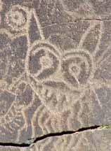 |
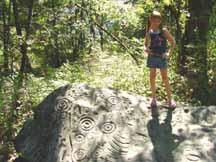
Continuing on, we soon came upon Horse Thief State Park where we viewed the many Indian petroglyphs that they have displayed here. When the Dalles Dam was being built, there was a concerted effort to remove and save a few of the many thousands of Indian petroglyphs that once lined the riverbanks. Some of these are now displayed here in a section of the park. We particularly enjoyed these including the one that resembles a cat. The Lewis and Clark party camped in this area and the following is reported on October 24, 1805: "... stopped in a deep bend of the river towards the right, and encamped a little above a large village of twenty-one houses. Here we landed, and as it was late before all the canoes joined us, we were obliged to remain here this evening ..." Clark reported: "... and proceeded down with the Canoes two at a time to a village of 20 wood housies in a Deep bend to the Stard. Side ..." They noted that the houses were made of wood, which was much different than the Indian huts of woven mats that they had become used to seeing.
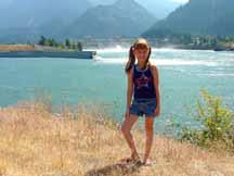 |
Our next stop was at a place much further down river just below Bonneville Dam where Lewis and Clark endured their difficult passage of the "Grand Shute" or "Great Shute" (the Cascade Rapids or Lower Falls) of the Columbia River. Here, on October 30 thru November 1, 1805, they again had to portage a long way around Columbia River rapids. An Indian village was located here at the head of the rapids and they wrote detailed descriptions of it in their journals when they passed by here on their return journey. On first reaching this area, the journals describe the situation as follows: " ... landed on an island very near the right shore at the head of the great shoot [The Lower Falls], and opposite two smaller islands at the fall or shoot itself. Just above the island on which we were encamped [today this island is underwater] is a small village of eight large houses in a bend on the right, where the country, from having been very mountainous, becomes low for a short distance. We had made fifteen miles to-day, during all which time we were kept constantly wet with the rain. As soon as we landed, captain Lewis went with five men to the village, which is situated near the river, with ponds in the low grounds behind: the greater part of the inhabitants were absent collecting roots down the river: the few, however, who were at home, treated him very kindly, and gave him berries, nuts, and fish; and in the house were a gun and several articles which must have been procured from the whites; but not being able to procure any information, he returned to the island. Captain Clarke had in the meantime gone down to examine the shoot, and to discover the best route for a portage. He followed an Indian path, which, at the distance of a mile, led to a village on an elevated situation. After going about three miles the night obliged him to return to camp: he resumed his search in the morning. Captain Clarke proceeded along the same path he had taken before, which led him through a thick wood and along a hill side, till two and a half miles below the shoots, he struck the river at the place whence the Indians make their portage to the head of the shoot: he here sent Crusatte, the principal waterman, up the stream, to examine if it were practicable to bring the canoes down the water. In the meantime, he, with Joseph Fields, continued his route down the river, along which the rapids seem to stretch as far as he could see. At half a mile below the end of the portage [the portage was across the Table Mountain Landslide], he came to a house, the only remnant of a town, which, from its appearance, must have been of great antiquity. The house was uninhabited, and being old and decayed, he felt no disposition to encounter the fleas, which abound in every situation of that kind, and therefore did not enter. About half a mile below this house, in a very thick part of the woods, is an ancient burial place: it consists of eight vaults. After examining this place captain Clarke went on, and found the river as before strewed with large rocks, against which the water ran with great rapidity. Just below the vaults the mountain, which is but low on the right side, leaves the river, and is succeeded by an open stony level, which extends down the river, while on the left the mountain is still high and rugged. At two miles distance he came to a village of four houses, which were now vacant and the doors barred up: on looking in he saw the usual quantity of utensils still remaining, from which he concluded that the inhabitants were at no great distance collecting roots or hunting, in order to lay in their supply of food for the winter: he left them and went on three miles to a difficult rocky rapid, which was the last in view." At this point Clark wrote the following: "I observed at this lower rapid the remains of a large and antient Village which I could plainly trace by the Sinks in which they had formed their houses, as also those in which they had buried their fish -- from this rapid to the lower end of the portage the river is Crouded with rocks of various Sizes between which the water passes with great velociety createing in maney places large Waves, an Island [Bradford Island] which is Situated near the Lard. Side occupies about half the distance the lower point of which is at this rapid. immediately below this rapid the high water passes through a narrow Chanel through the Stard. Bottom forming an Island of 3 miles (wide) Long & one wide [Hamilton Island], I walked through this Island which I found to be verry rich land, and had every appearance of haveing been at Some distant period Cultivated. at this time it is Covered with grass intersperced with Strawberry vines . I observed Several places on this Island where the nativs had dug for roots and from its lower point I observed 5 Indians in a Canoe below the upper point of an Island near the middle of the river Covered with tall timber, which indued me to believe that a village was at no great distanc below, I could not See any rapids below in the extent of my view which was for a long distance down the river, which from the last rapids widened and had everry appearance of being effected by the tide, -- I deturmind to return to Camp 10 miles distant". As Clark mentioned, he finally ended his scouting trek about 10 miles from camp, which was located at the head of the rapids, and he discovered what looked to him like tidal waters, a clue that it would be smooth sailing once these rapids were traversed.
 |
 |
This particular area is also where Oregon Trail emigrants encountered a tough situation with the rapids, which involved long and difficult portages around the tumultuous cascades. After passing around the rapids, they were forced to build rafts or hire boats to travel the rest of the river down to Fort Vancouver or Oregon City. This place then became a small town where steamboats came to pick up passengers and where others stayed to service travelers. Now, this area is a wild landscape of river and forest with an interpretive loop trail that stretches about three miles. Katelyn seemed to have no problem going the distance on the trail and actually enjoyed the walk through the thick woods where signs pointed out where the locations of certain buildings once stood, or where the wagon road or a railroad bed (with actual remnants of tracks) was once located.
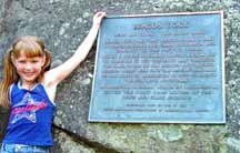 |
Next, after a short distance down the road we came upon Beacon Rock State Park and stopped for a short time to take pictures. This monolith is the 848-foot high core of an ancient volcano that the Columbia River revealed after washing away its outer walls. It stands alone with its dark basalt columns standing erect above the river and surrounding forest. William Clark wrote in his journal on October 31, 1805 the following: "... a remarkable detached rock stands in a bottom on the stard side near the lower point of this island on the stard side about 800 feet high and 400 paces around, we call the Beaten (Beacon) Rock." After viewing this object of natures handiwork, we were soon on our way and it was not long before we were entering the city of Vancouver and locating our next overnight stay at an RV park.
| Previous | Top | Next |